الوضع الليلي


 10:24:11
  2026-06-06
  1280
1280
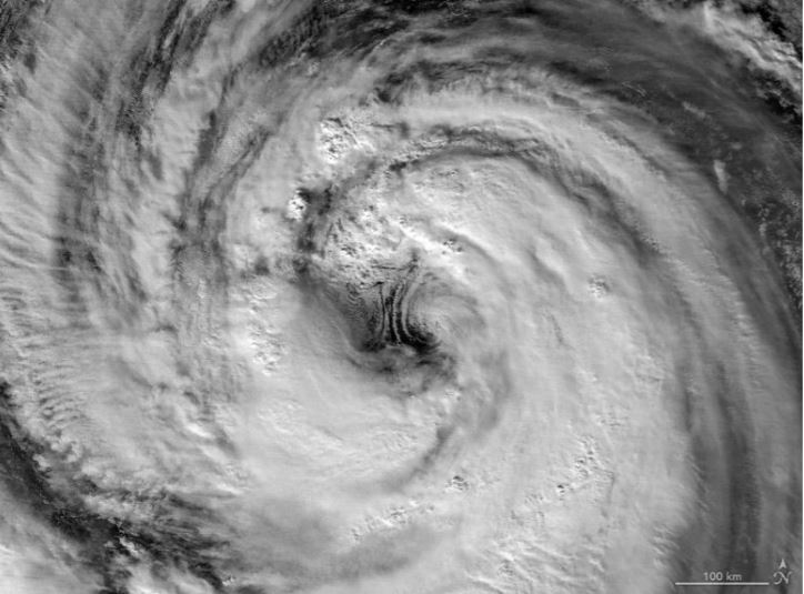
Typhoon Jangmi dazzled from space with a giant swirling eye while drenching parts of Japan with heavy rain.
From late May into early June 2026, Typhoon Jangmi slowly tracked north-northwest across the Philippine Sea on a path toward southern Japan. Although the storm moved at a relatively slow pace, it spread intense rainfall across a large area, raising concerns about flooding in several locations.
A dramatic nighttime image (above) captured by the VIIRS (Visible Infrared Imaging Radiometer Suite) instrument aboard the Suomi NPP satellite shows the typhoon on May 30 at approximately 16:40 Universal Time (1:40 a.m. Japan Standard Time on May 31).
At that time, the Joint Typhoon Warning Center (JTWC) reported sustained winds of 120 kilometers (75 miles) per hour based on 1-minute averages. That wind speed is comparable to a Category 1 hurricane on the Saffir-Simpson hurricane wind scale.
Giant Storm Eye Visible from Space
The satellite image provides a remarkably clear look at the storm’s eye and surrounding eyewall. According to Scott Braun, a research meteorologist at NASA’s Goddard Space Flight Center, the eye was larger than average compared with many tropical cyclones.
Braun also noted signs of low-level rotation along the eastern side of the eye. These rotating features, known as mesocyclones, can be seen beneath higher clouds that partially obscure them. While visually striking, Braun explained that such features are a normal part of storms like Jangmi.
Storm Strengthens Near Okinawa
A second satellite image (above), collected one day later by the VIIRS instrument aboard the NOAA-20 satellite, shows the same storm after it gained additional strength. The image was acquired at approximately 16:40 Universal Time on May 31 (1:40 a.m. Japan Standard Time on June 1).
By then, Jangmi’s sustained winds had increased to 130 kilometers (80 miles) per hour, making it a somewhat stronger typhoon than it had been the previous day.
In both satellite views, the center of the storm remained south of Okinawa. Even so, its expansive outer cloud bands had already extended across parts of Japan as the system continued moving northward.
Forecasts indicated that Jangmi would pass close to Okinawa before curving northeast toward the Amami region around June 1-2. News report also warned that the storm was expected to continue producing significant rainfall, particularly along Japan’s Pacific coastline.
Reality Of Islam |
|
Two experim

Changing a

Plants are

After spend
 9:3:43
2018-11-05
9:3:43
2018-11-05
10 benefits of Marriage in Islam
7:5:22
2019-04-08
benefits of reciting surat yunus, hud &
9:45:7
2018-12-24
advantages & disadvantages of divorce
11:35:12
2018-06-10
6:0:51
2018-10-16
the happy life of mankind requirement
6:36:36
2022-01-25
10:47:11
2022-11-22
11:34:48
2022-06-29
2:42:26
2023-02-02
4:26:43
2022-02-21
8:21:9
2018-06-21
3:43:50
2022-11-05
5:41:46
2023-03-18
| LATEST |
 HOME
HOME